Understanding LiDAR Scanning Technology

As urban landscapes evolve, understanding the technologies that shape them becomes increasingly essential. One such innovation is LiDAR scanning, a powerful tool that reveals the intricacies of our environment. How can this technology transform urban planning and development? Let’s explore its key benefits and applications.
What You Will Learn
- LiDAR technology utilizes laser pulses to create precise, three-dimensional representations of landscapes.
- The Time of Flight (ToF) principle allows for rapid, accurate measurements over large areas, essential for urban planning.
- Airborne LiDAR is effective for mapping large geographical areas, whereas Terrestrial Laser Scanning (TLS) excels in detailed measurements of smaller sites.
- Integrating LiDAR with Geographic Information Systems (GIS) enhances data visualization and assists in making informed urban development decisions.
- LiDAR applications extend to various industries, including construction, where it improves site surveys, progress monitoring, and quality control.
LiDAR Technology: Comparison of Types and Applications
A visual overview of LiDAR's core principles, distinct scanning methods, and its diverse real-world applications.
How LiDAR Works: Time of Flight (ToF)
LiDAR emits laser pulses and measures the time it takes for them to return after hitting an object. This "Time of Flight" principle calculates precise distances, creating accurate 3D models.
- • Emits Laser Pulses
- • Measures Return Time
- • Calculates Distance & 3D Points
3D Point Clouds: The Output
Laser pulses generate a dense collection of points known as a 3D point cloud. This cloud represents scanned surfaces, enabling detailed visualizations and models for various analyses.
- • Dense Point Collection
- • Represents Scanned Surfaces
- • Used for Detailed Models
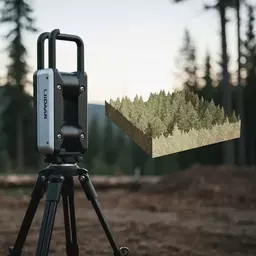
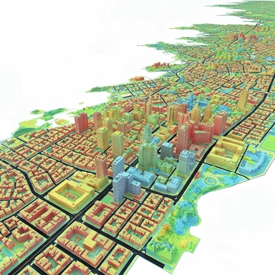
Airborne LiDAR
Ideal for large-scale mapping, covering extensive landscapes from aircraft. Benefits include topographic mapping and vegetation analysis.
- • Large Area Coverage
- • Topographic Mapping
- • Vegetation Analysis
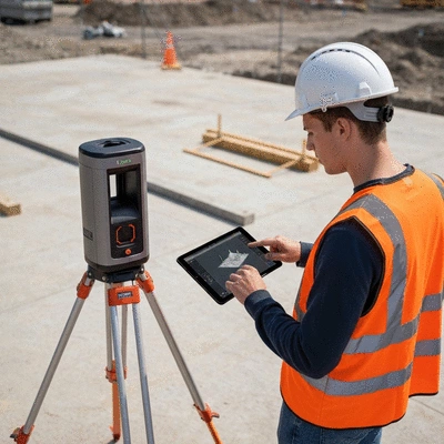
Terrestrial Laser Scanning (TLS)
Provides ultra-precise measurements for smaller, detailed areas, crucial for construction and historical preservation.
- • Precision Measurements
- • Existing Structures Assessment
- • Enhanced Detail Capture
LiDAR & GIS Integration
Integrating LiDAR data with GIS enhances spatial analysis and visualization, offering a holistic view for informed urban planning.
- • Enhanced Data Visualization
- • Better Decision-Making
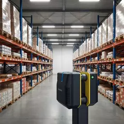
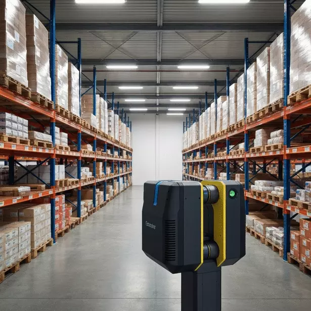
LiDAR in Construction
Improves accuracy and efficiency in construction through accurate site surveys, progress monitoring, and quality control.
- • Site Surveys
- • Progress Monitoring
- • Quality Control
Understanding LiDAR Scanning Technology
LiDAR (Light Detection and Ranging) is an innovative technology that has transformed the way we capture and analyze spatial data. By using laser pulses to measure distances, LiDAR enables us to create highly accurate, three-dimensional representations of the Earth's surface and objects on it. As an urban development enthusiast at Urban Property Insights, I've seen firsthand how this technology can enhance urban planning and development projects!
What is LiDAR and How Does It Work?
At its core, LiDAR technology works by emitting laser beams and measuring the time it takes for them to bounce back after hitting an object. This is known as the Time of Flight (ToF) principle. By calculating the elapsed time, we can determine the distance between the sensor and the object, which is vital for creating accurate 3D models of landscapes and urban environments.
Defining LiDAR Technology Using Time of Flight (ToF)
The ToF method is essential because it allows us to gather precise measurements over large areas quickly. This efficiency makes LiDAR ideal for urban settings where time is often of the essence. For instance, in real estate development, understanding the topography and existing structures accurately can save invaluable time in the planning process.
The Role of Laser Pulses in Generating 3D Point Clouds
When laser pulses are fired, they create a dense collection of points known as a 3D point cloud. This point cloud represents the scanned surfaces and can be processed to produce detailed visualizations and models. The richness of information captured in these point clouds is crucial for tasks like assessing land use, managing construction projects, and even environmental monitoring!
Types of LiDAR Scans: Airborne vs. Terrestrial
LiDAR scanning comes in two primary forms: airborne and terrestrial. Each type has its unique applications and benefits, tailored to different needs and industries. Understanding these differences can help urban professionals and investors like you make informed decisions about the best approach for your projects.
Exploring Airborne LiDAR: Applications and Benefits
- Large Area Coverage: Airborne LiDAR can efficiently cover extensive landscapes, making it ideal for mapping entire cities or large geographical areas.
- Topographic Mapping: It provides accurate terrain models that assist in flood modeling and natural resource management.
- Vegetation Analysis: This method allows for the assessment of forest canopy heights and biomass, which is essential in environmental studies.
These benefits highlight why airborne LiDAR is becoming a go-to tool for city planners and environmentalists alike—its ability to deliver high-quality data quickly is unmatched!
Advantages of Terrestrial Laser Scanning (TLS) in Various Industries
- Precision Measurements: TLS offers incredibly precise measurements that are vital for construction sites and architectural planning.
- Assessing Existing Structures: It is extensively used for inspecting and documenting historical buildings and infrastructures.
- Enhanced Detail: TLS captures intricate details of smaller areas, making it suitable for urban environments where precision is crucial.
With these advantages, TLS technology plays a critical role in ensuring that urban development projects meet both aesthetic and functional requirements, contributing to sustainable metropolitan growth.
Integrating LiDAR with Geographic Information Systems (GIS)
Integrating LiDAR data with Geographic Information Systems (GIS) enhances the visualization and analysis capabilities of spatial information. As someone who follows urban development trends, I can tell you that this integration provides a holistic view of urban landscapes, making it easier to identify patterns and make informed decisions.
The Importance of GIS in Enhancing LiDAR Data Visualization
GIS platforms allow us to overlay LiDAR data with other datasets, such as demographics and zoning regulations. This combination helps urban planners visualize how different factors interact within a given space, leading to better decision-making in real estate investments.
How Remote Sensing Complements LiDAR Technology
Remote sensing plays a complementary role by providing additional context to the LiDAR data. For example, satellite imagery can offer insights into land use changes over time, while LiDAR gives us a precise snapshot of the current topography. Together, these technologies create a comprehensive toolkit for analyzing and understanding our urban environments!
Quick Poll: Your Thoughts on LiDAR Technology
As we've explored the transformative impact of LiDAR technology in urban planning and various industries, we want to hear from you! How do you see LiDAR shaping the future of urban development?
Applications of LiDAR Scanning in Real-World Scenarios
LiDAR scanning technology is not just a buzzword—it's transforming how we approach various fields, from urban planning to environmental research. At Urban Property Insights, we've seen firsthand how these innovations can empower urban professionals and investors alike. Here’s a look at some of the innovative applications that harness the power of LiDAR scanning.
Innovative Uses of LiDAR in Research and Development
LiDAR technology is driving progress in many research areas. One fascinating application is in Feature Extraction for Simultaneous Localization and Mapping (SLAM). This method allows autonomous systems, like drones and robots, to navigate and map their environments accurately. By leveraging LiDAR’s precise measurements, these systems can understand their surroundings in real time, which is crucial for efficiency and safety.
- Enhanced mapping capabilities: LiDAR helps in creating detailed 3D maps that improve navigation.
- Increased accuracy: The use of laser pulses ensures that the data collected is precise and reliable.
- Real-time processing: SLAM applications benefit from the speed at which LiDAR can process data, allowing for immediate adjustments.
Another exciting application is in Dynamic Target Detection, which plays a significant role in robotics and visual search applications. By using LiDAR data, robots can identify and track moving objects, enhancing their operational capabilities. This is particularly useful in fields such as logistics, where efficiency is key!
Practical Applications in Different Industries
Across various industries, LiDAR technology is proving to be a game changer. In the construction sector, for example, LiDAR scanning enhances project accuracy and efficiency in several ways:
- Site surveys: LiDAR provides quick and accurate topographical data, saving time during the planning phase.
- Progress monitoring: Regular scans allow project managers to track construction progress accurately, ensuring timelines are met.
- Quality control: With precise data, teams can detect discrepancies early and address them before they escalate into costly delays.
By integrating LiDAR technology into construction workflows, businesses can not only save time but also reduce costs and improve overall project outcomes. As an urban development enthusiast, I can’t stress enough the importance of adopting innovative technologies like LiDAR in our rapidly evolving landscapes.
Frequently Asked Questions (FAQs) about LiDAR Technology
- What is LiDAR technology?
- LiDAR (Light Detection and Ranging) is a remote sensing method that uses pulsed laser light to measure distances to the Earth's surface, creating precise, three-dimensional representations of landscapes and objects.
- How does LiDAR work?
- LiDAR operates on the Time of Flight (ToF) principle. It emits laser pulses and measures the time it takes for these pulses to return after reflecting off an object. This elapsed time is used to calculate the distance and generate accurate 3D models and point clouds.
- What are the main types of LiDAR scans?
- The two primary types are Airborne LiDAR, which is used for large-scale mapping from aircraft, and Terrestrial Laser Scanning (TLS), which provides highly precise measurements for smaller, detailed areas from ground-based scanners.
- How is LiDAR used in urban planning?
- LiDAR is crucial for urban planning as it provides accurate topographic data, assists in flood modeling, vegetation analysis, and enhances data visualization when integrated with Geographic Information Systems (GIS). This helps urban planners make informed decisions.
- What are some practical applications of LiDAR in industries?
- LiDAR is used in various industries. In construction, it improves site surveys, monitors progress, and ensures quality control. In research and development, it's vital for applications like Simultaneous Localization and Mapping (SLAM) for autonomous systems and dynamic target detection in robotics.
Recap of Key Points
Here is a quick recap of the important points discussed in the article:
- Understanding LiDAR Technology: LiDAR uses laser pulses to measure distances and create 3D representations of surfaces, enhancing urban planning and development.
- Time of Flight Principle: This principle allows for quick and precise measurements over large areas, crucial for urban settings.
- Types of LiDAR Scans: Airborne LiDAR is ideal for large area coverage and topographic mapping, while Terrestrial Laser Scanning (TLS) offers precision for assessing existing structures.
- Integration with GIS: Combining LiDAR data with Geographic Information Systems enhances spatial analysis and decision-making for urban planners.
- Innovative Applications: LiDAR is transforming industries through applications like SLAM for autonomous systems and dynamic target detection in robotics.